

Skyway, Chinnabee, Pinho Loop
a281南路亚当峡步道入口,只有3人.8 miles south of
Cheaha State Park.
Hospital
坦纳医疗中心/东阿拉巴马
艾尔36278,Wedowee, Main St S 1032号
+12563572111
Clinic
克莱县诊所
60026 AL-49, Lineville, AL 36266
+12563962141
Call 911
Call Ranger Station
- 塔拉迪加游侠区
- (256)362-2909
Call Emergency Contact
前往最近的营地或十字路口
总是听从紧急救援人员的指示
不要在恶劣天气下徒步旅行,寻找避风处.
Don’t forget to check the weather before you leave.
Look For:
- lightning
- Tornado conditions
- flash flood warnings
- 看雷达预报.
不要与野生动物接触. 保持安全和尊重的距离.
Remember Leave No Trace:
- Plan ahead and Prepare
- 露营和旅行在耐用的表面
- Dispose of Waste Properly
- Respect Others
- Respect Wildlife
- Minimize Campfire Impact
- Leave What You Find
trail data.
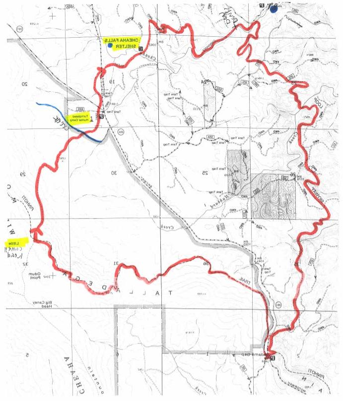
Trails Covered ~ Pinho Trail, Chinnabee Silent Trail, Skyway Loop Trail
远足地点:南切哈荒野
徒步方向~逆时针方向
Hike Distance ~ 16.7 miles
开始/结束徒步旅行~ Adams Gap Trailhead
Terrain / Difficult ~ 0.0 ~ 8.0 rocky climbs and descents, rock bluffs and rock gardens.
Moderate ~ 8.0 ~ 16.7 rolling hills. 有3个中等大小的河口 the Chinnabee and Skyway area, use extreme caution after heavy rains.
hiker services.
CS ~ Convenience Store / Nice Mom and Pop stores ~ 0
TT ~ Trail Town / Large enough for McDonald's ~ 0
SC ~ Small Campsite / At least one tent site ~ 4.4
LC ~ Large Campsite / At least three tent sites ~ 3.1, 4.8, 5.4, 5.8, 6.0, 7.6, 7.8,
9.0, 11.0, 12.7, 15.7
TS ~ Trail Shelter /三面,正面开放~ 9.2
SW ~ Seasonal Water / Needs rain in the past week ~ 1.2, 2.5, 3.2, 5.5, 5.9, 6.0,
6.9, 8.2, 16.4.可靠的水/随时可用~ 7.6, 9.0, 11.0, 11.4, 12.7,
12.8, 15.7
Trail Description:
为了更容易的徒步旅行,顺时针走一圈 . 请注意以下说明
你想逆时针走吗.
This 16.7 mile counter-clockwise loop begins at the southwestern end of the Cheaha
亚当斯峡步道起点的荒野. 从停车场,你会穿过AL
281 and go down the small downhill paved road about 10 feet to the Pinho Trail. Turn
在Pinho上左转,然后徒步旅行.0英里到小坎尼岬营地. Then turn
左转到钦纳比寂静小径徒步旅行.4 miles to Lake Chinnabee. Just before
the lake you'll turn left on the Skyway Loop Trail and then hike 5.1 miles to the
Pinho Trail. 在Pinho上左转,然后徒步0.还有2英里到亚当斯峡小道.
Trail Marking:
Wilderness Standards do not allow trail blazing in protected areas ~ mile 0.0 thru
8.0.
The western half of the Chinnabee and all of the Skyway Trail are well blazed.
me vs distance
To help you judge the me needed to travel from point A to point B,
假设徒步旅行的平均速度是每小时2英里:
60 minutes = 2 miles
30 minutes = 1 mile
15 minutes = 1/2 mile
driving directions.
0.0 ~ ADAMS GAP TRAILHEAD
431号国道I ~ 20号出口,牛津以东.
Go south 3.离高架桥还有4英里.
Go 100 yards past the overhead bridge to the second right turn, just before the Cheaha
Store. Turn right.
Go 0.还有4英里到al281的停车标志. Turn le.
Go 17.9 miles to where the pavement ends at the Adams Gap Trailhead parking area.
trail guide.
0.0 ~ Adams gap trailhead / al 281 ~ 1444'
From the parking area, cross over AL 281 and go down the small downhill paved road
for about
10' and turn le up the hill into the Cheaha Wilderness.
0.1 ~ CHEAHA WILDERNESS BOUNDARY / INFO BOARD ~ 1500'
1.2 thru 2.5 ~ 6个泉水口~ 1360′+/- ~ sw
3.1 ~营地~ 1380′~ lc, sw
There is a fire ring here on the le and the spring crossing is at mile 3.2.
3.2 ~春季渡口~西南~ 1360′
3.5 ~招牌/路基~ 1460′
The trail turns right on the road bed and goes 0.2 miles.
3.7 ~ SIGN BOARD ~ 1575'
这条路一直延伸到小河边的树林里. 这个指示牌在10号路外
le and is easy to miss.
3.7 ~通往天堂的阶梯~ 1575英尺
Here is a huge rock garden and there are a lot of tricky little uphill rocky
下一个0的转换.5 miles. 密切注意火势!
4.3 ~ PEARLY GATES ~ 2050'
你必须亲眼看到才会相信. Yikes!
4.4 ~天/岩顶4 ~ 2135′~ sc
There is a hidden rocky overlook on the le as you scramble your way around the
north side of the peak.
WILDFLOWER ~ Mountain Laurel / Late Spring / White.
4.8 ~ 5.4 ~ 3个营地~ 2100英尺+/- ~ LC ~视野好
5.5 ~春季穿越~ 2140′~西南
5.7 ~ ROCKY TOP 5 ~ 2160'5.8 ~营地~ 2120英尺~ LC ~视野好
5.9 ~春季穿越~ 2120′~西南
6.0 ~ LITTLE CANEY HEAD CAMPSITE / CHINNABEE SILENT TRAIL ~ 2100' ~ LC, SW
Turn left at this big intersection on the Chinnabee Silent Trail and start working
从山脊上下来.
LC ~ Little Caney Head is a busy place with 6 fire rings.
SW ~弹簧在CST下50',在le上. 这是一个高脊泉,因此
it is reliably unreliable year round - plan accordingly.
WILDFLOWER ~ Mountain Laurel / Late Spring / White
6.9 ~ SPRING CROSSING ~ SW
The spring is off trail about 50' to the right, through a Mountain Laurel thicket.
You'll be able to hear it a lot beer than you can see it.
7.6 ~渡河~ lc, rw
7.萝卜猎人营地~ lc, rw
这条小路直接穿过营地的路. 你可以在50分左右上路
yards to a new outhouse.
8.0 ~ al 281十字路口/停车区
这条小路一直穿过马路.
8.2 ~ SPRING CROSSING ~ SW
穿过泉水,小路向左拐.
8.5 ~高架公路高速公路交叉口
这条小路一直穿过马路.
9.0 ~ cheaha落~ lc, rw
过了小溪,小路就左转了. 瀑布在河下游50英尺处.
LC ~ There is a large campsite on the right, before the creek crossing.
FORDING HAZARD: Use extreme caution after heavy rains.
9.2 ~ cheaha瀑布避难所~ ts
The trail turns sharp right just past the shelter. 这个避难所以前是已知的
就像小树头避难所一样. It was flown over here by helicopter in 1993 from
小Caneyhead营地.
The water source for the shelter is Cheaha Falls.
10.5 ~ PINE BEETLE CUT
11.0 ~ CAMPSITE ~ LC, RW
去那边找营地.
11.2 ~魔窟脚桥
This 75' bridge has good views of the chaos below in Devil's Den.
11.4 ~ TRAIL SIGN / SKYWAY LOOP TRAIL INTERSECTION ~ RW
Continue on for another 50' past this sign to the Skyway Loop Trail sign. Turn le
here and cross the creek.
FORDING HAZARD: Use extreme caution after heavy rains.
12.0 ~ ROAD BED CROSSING
12.2 ~ ROAD BED CROSSING
12.7 ~ CAMPSITE ~ LC, RW
Look for a trail on the right leading to the camp.
12.8 ~哈伯德溪渡~ rw
FORDING HAZARD: Use extreme caution after heavy rains.
13.7 ~ ROAD BED CROSSING
14.7 ~ ROAD BED CROSSING
15.7 ~ CAMPSITE ~ LC, RW
营地在左边和右边.
15.8 ~民间环保兵团烟囱
Many years ago there was a CCC Park Cabin on this spot. 注意上坡
switchbacks ahead.
16.4 ~ SPRING CROSSING ~ SW
16.5 ~ pinhoti步道交叉口~ 1400′
When you come to the intersection, turn le on the Pinho and follow the rocky
trail up to the gap.
16.7 ~亚当斯峡步道起点~ 1444′
这次旅行你至少需要4顿饭.
Veggie Wraps:
- hummus, tortillas, tomato, spinach, cucumber, and cheese
- Spaghetti noodles, sauce, green pepper, mushrooms
Granola - granola, evaporated milk (add water), dried berries
Ramen Soup - 拉面,混合蔬菜,咖喱,椰奶